Scan the horizon from Lake Michigan’s shore and you will see nothing — no opposite bank, no far shore, just water meeting sky like an ocean. That is not an illusion. Lake Michigan is bigger than West Virginia, deeper than most people guess, and more ecologically complex than almost any lake on Earth. Here is the full picture.
How Big Is Lake Michigan? The Core Dimensions
| Measurement | Imperial | Metric |
|---|---|---|
| Surface area | 22,404 sq miles | 58,030 km² |
| Length (N–S) | ~307 miles | ~494 km |
| Width (widest) | ~118 miles | ~190 km |
| Volume | ~1,180 cubic miles | 4,920 km³ |
| Shoreline length | ~1,640 miles | ~2,640 km |
| Maximum depth | 923 feet | 281 m |
| Average depth | 279 feet | 85 m |
| Elevation | 577 feet above sea level | 176 m |
Lake Michigan Length, Width, and Shape
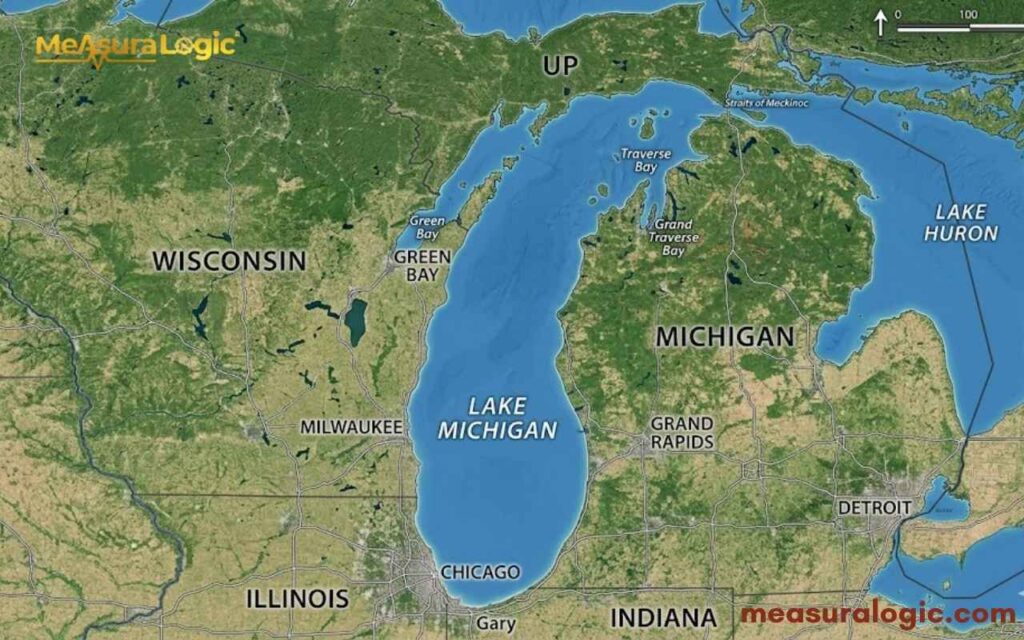
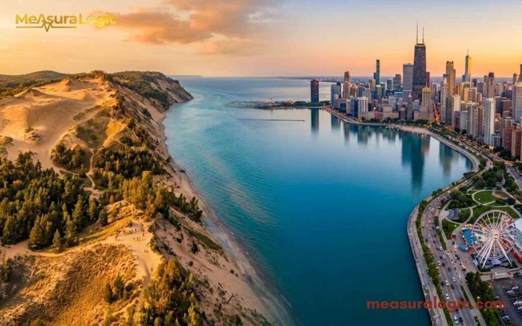
The lake runs 307 miles north to south and 118 miles at its widest point, an elongated oval tilted slightly northwest to southeast. That north-south orientation funnels cold Arctic air in winter, producing legendary lake-effect snow on the eastern shore. The narrow southern tip touches Illinois and Indiana, which is why Chicago sits at the lake’s heel.
Explore About How Big Is Chicago? Exploring the Size, Layout, and its Charm
Volume and What It Means
1,180 cubic miles of water sounds abstract. Think of it this way, if you drained Lake Michigan and spread its water across the contiguous 48 U.S. states, every square inch would sit under roughly 1.3 feet of water. That volume is why over 12 million people across Chicago, Milwaukee, and dozens of smaller cities drink from this lake daily.
Shoreline Length
The official Lake Michigan shoreline length is 1,640 miles — a figure that depends on scale of measurement, thanks to the coastline paradox. Detailed measurements including bays and inlets push it higher. What’s certain is that those miles run through four states and span some of the most ecologically varied coastal terrain in North America.
How Deep Is Lake Michigan?
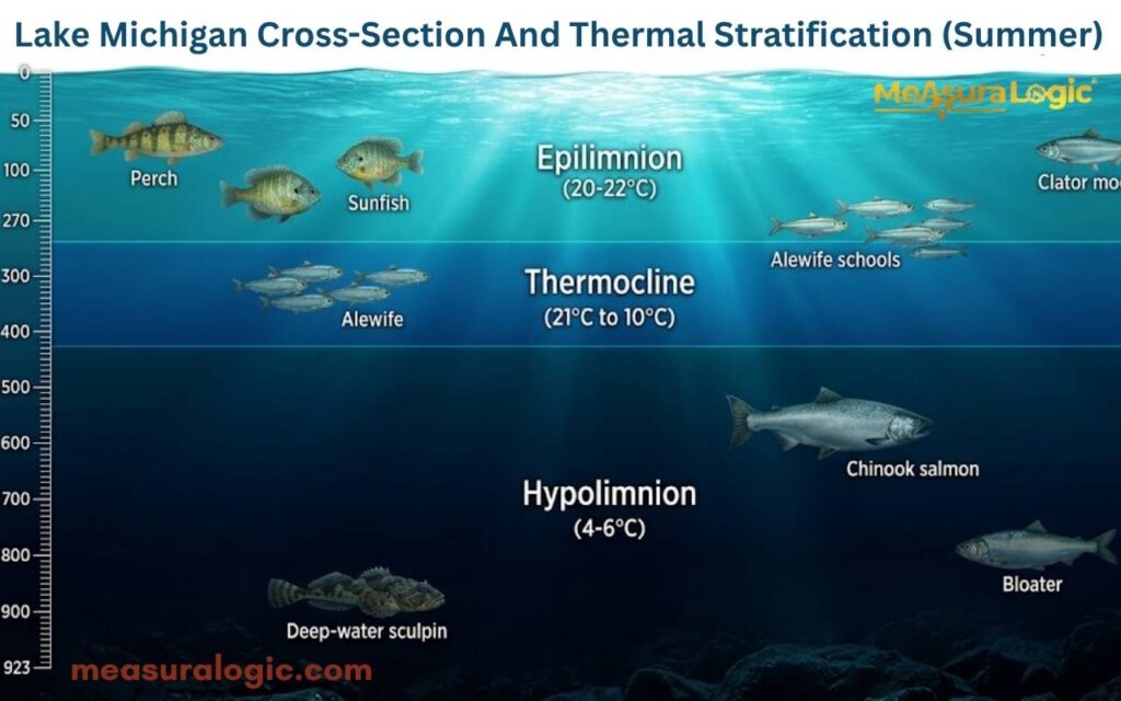
Depth is not a single number here, it is a layered story. Understanding its depth means looking beyond the dramatic maximum and asking what the average depth actually controls day to day.
Maximum vs. Average Depth
The 923-foot maximum depth sits in the northern basin near Cheboygan, Michigan — carved by glaciers during the last Ice Age. But the average depth of 279 feet matters more for understanding how the lake actually behaves. That average governs:
- Thermal stratification: Warm surface water sits above cold deep water each summer, separated by a sharp thermocline
- Storm intensity: Deeper water stores more thermal energy, fueling powerful autumn storms
- Fall turnover: Every autumn, cooling surface water sinks, circulating nutrients from the bottom upward
The North-South Divide
An underwater ridge splits the lake roughly east to west. The deeper northern basin supports cold-water species like lake trout. The shallower, warmer southern basin near Chicago and Indiana sees more intense algae blooms and hosts different fish communities entirely.
Lake Michigan Size vs. Other Lakes
Here is how Lake Michigan’s dimensions stack up, first against its Great Lakes neighbors, then against the largest lakes on Earth.
Find about 20 everyday Items That Are 7 Inches Long
Great Lakes Size Comparison
Here is what both competitors miss: Lake Michigan and Lake Huron are technically one water body, connected at the Straits of Mackinac and sharing the same 577-foot surface elevation. As a combined system, Michigan-Huron is the largest freshwater lake on Earth by surface area — bigger than Lake Superior.
Treated separately, here is how the Great Lakes compare:
| Lake | Surface Area (sq mi) | Max Depth (ft) | Volume (cubic mi) |
|---|---|---|---|
| Superior | 31,700 | 1,332 | 2,900 |
| Huron | 23,000 | 750 | 850 |
| Michigan | 22,404 | 923 | 1,180 |
| Erie | 9,910 | 210 | 116 |
| Ontario | 7,340 | 802 | 393 |
Lake Michigan vs Lake Superior: Superior wins on every dimension but Michigan still holds more water than Lake Erie and Lake Ontario combined.
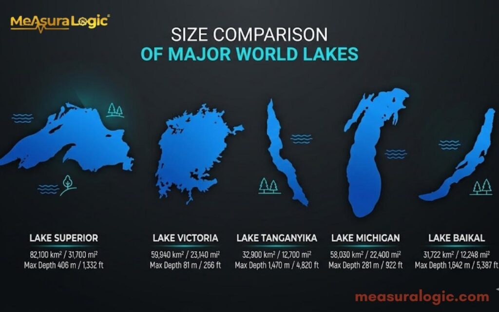
Global Lake Comparison
| Lake | Location | Surface Area (sq mi) | Notable For |
|---|---|---|---|
| Superior | North America | 31,700 | Largest freshwater lake by area |
| Victoria | Africa | 26,600 | Shallowest of the top three |
| Michigan | North America | 22,404 | Only Great Lake entirely in USA |
| Tanganyika | Africa | 12,700 | Deepest in Africa — 4,823 ft |
| Baikal | Russia | 12,248 | World’s deepest — 5,387 ft |
Lake Michigan vs Lake Baikal: Baikal is far smaller in surface area but holds roughly 20% of Earth’s unfrozen fresh water due to extreme depth. Michigan wins on area; Baikal on volume. The Great Lakes collectively hold 21% of Earth’s surface fresh water — Michigan is a cornerstone of that figure.
The Shoreline: What 1,640 Miles Actually Looks Like
The coastal areas of Lake Michigan look nothing alike from state to state.
- Wisconsin — bluffs, bays, and the Door Peninsula, often called the “Cape Cod of the Midwest”
- Illinois — just 63 miles, almost entirely urban; Chicago’s Lakefront Trail is one of the great city waterfronts anywhere
- Indiana — only 45 miles, but home to Indiana Dunes National Park, with freshwater dunes rising 200 feet; one of North America’s most biodiverse temperate zones
- Michigan — the longest stretch, anchored by Sleeping Bear Dunes National Lakeshore where perched dunes tower 400 feet above the water
Lake Michigan Islands
| Island | Size | Known For |
|---|---|---|
| Mackinac Island | 3.8 sq mi | No cars; most visited Great Lakes island |
| Beaver Island | 55 sq mi | Largest Michigan island; year-round community |
| North Manitou Island | 15 sq mi | Remote wilderness; ferry access only |
| South Manitou Island | 7.4 sq mi | Historic lighthouse; ancient cedar valley |
| Washington Island | ~35 sq mi | Off Door Peninsula, Wisconsin |
Learn About Tiny House Dimensions: Complete Guide to Sizes and Layouts
Water Quality and the Invasive Species Problem
Clean water and a healthy lake are not guaranteed, they are maintained, constantly, against real threats. Lake Michigan water quality is shaped as much by circulation patterns and human activity as by its sheer size.
How the Lake Circulates
Lake Michigan moves in a dominant counter-clockwise gyre — northward along Michigan’s shore, southward along Wisconsin’s. This is why beach closures for E. coli are localized: pollution follows the gyre, concentrates in bays, and can vanish from one beach while pooling at another nearby.
The lake’s water retention time is approximately 99 years. Water entering today would not fully cycle out for a century. Agricultural runoff, microplastics, and industrial pollutants accumulate over decades — which is why recovery from past water pollution is measured in generations, not years.
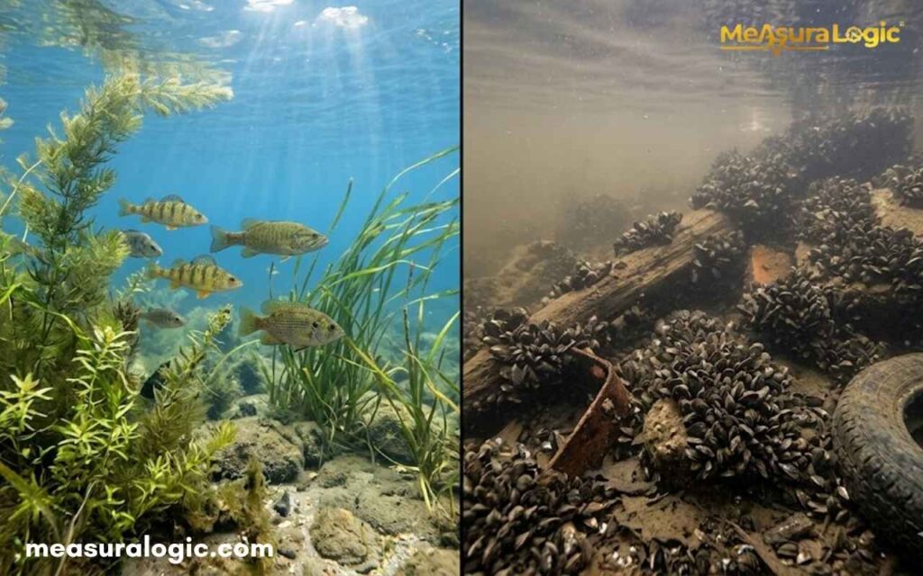
The Mussel Paradox
Zebra mussels arrived in the late 1980s via ballast water. Quagga mussels followed. Both filter phytoplankton so efficiently that water clarity in parts of southern Lake Michigan jumped from 10–15 feet visibility to 50–60 feet. Cleaner water sounds like a win. It wasn’t.
That phytoplankton was the base of the food chain for yellow perch, alewives, and salmon. Nearshore productivity collapsed. The freshwater ecosystem was restructured from the bottom up by two thumbnail-sized mollusks — one of the most consequential invasive species events in Great Lakes history.
Asian carp remain a live threat at the Chicago waterway connection. A $778 million barrier system at Brandon Road Lock and Dam is currently the main line of defense.
Economic Importance of Lake Michigan
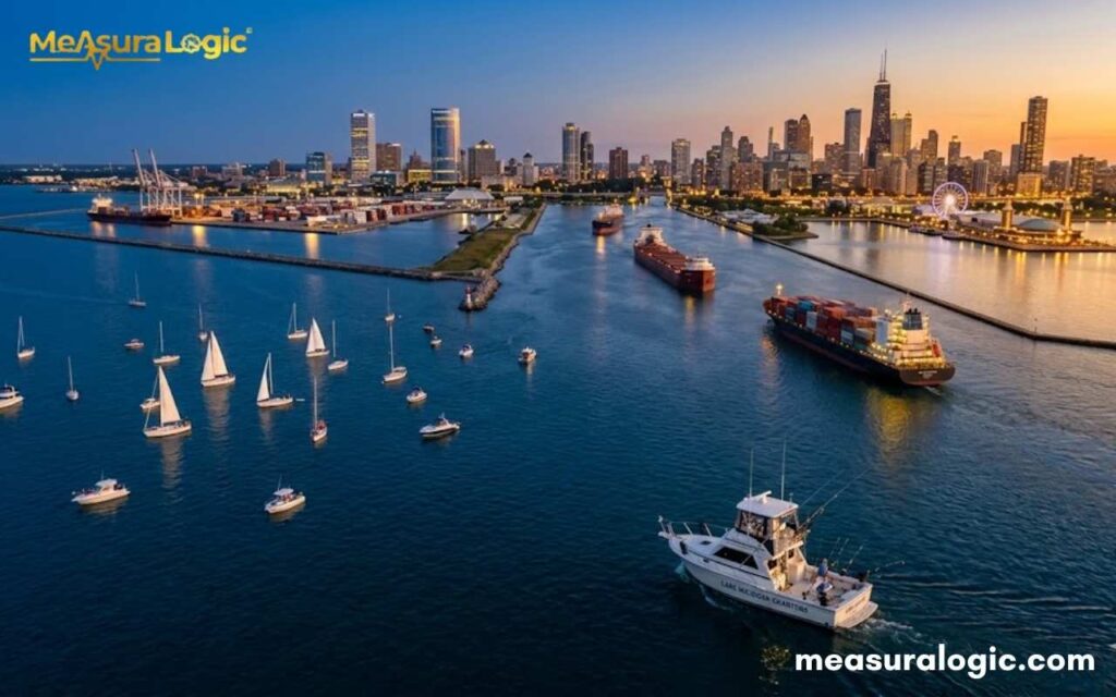
The lake is not just an ecological system, it is an economic engine. Its economic importance runs from heavy industry and commercial shipping all the way to beach tourism and sport fishing.
Ports and Shipping
The shipping industry on Lake Michigan connects to the Great Lakes–St. Lawrence Seaway, allowing ocean vessels to reach the interior of North America from the Atlantic. Key ports:
| Port | State | Primary Cargo |
|---|---|---|
| Chicago Harbor | Illinois | Containers, steel, grain |
| Milwaukee Port | Wisconsin | Salt, coal, steel |
| Green Bay Port | Wisconsin | Paper, salt, aggregate |
| Burns Harbor | Indiana | Steel |
Learn about 19 Items That Are 12 Inches Long
Fishing and Tourism
Commercial fishing focuses on lake whitefish and yellow perch, managed under state and tribal agreements. Tribal nations — particularly the Chippewa/Ojibwe — hold treaty-protected harvest rights throughout Michigan waters.
Tourism at Lake Michigan drives billions in regional revenue:
- Indiana Dunes National Park: 3+ million visitors annually
- Sleeping Bear Dunes National Lakeshore: 1.5+ million visitors annually
- Chicago’s lakefront: tens of millions of users each year
And the most essential economic use of all — drinking water for 12 million people, processed daily through facilities like Chicago’s Jardine Water Purification Plant, which handles over 700 million gallons per day.
The Future: Water Levels, Climate, and Conservation
The lake’s past is impressive. Its future is uncertain.
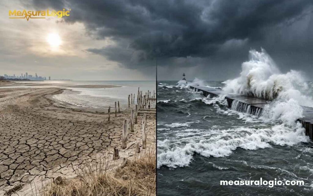
Record-Breaking Water Level Swings
Between 2013 and 2020, Lake Michigan’s surface level swung nearly 6 feet — historic low to near-record high in just seven years. Three drivers explain it:
- Precipitation — wetter winters pushed levels up after 2013
- Evaporation — warmer temperatures pull more water from the surface
- Ice cover decline — average winter ice cover dropped from ~90% in the 1970s to ~50–60% today, dramatically increasing winter evaporation
Climate change makes both extremes more likely — not gradual rise, but wilder swings between historic lows and record highs.
The Diversion Fight
The Great Lakes Compact of 2008 bans most water diversions outside the basin. As water scarcity grows across the American West and South, political pressure on this agreement intensifies every decade.
Read about 17 Common Things That Are 18 Inches Long (Real Life Examples)
What’s Actually Working
The Great Lakes Restoration Initiative (GLRI) has invested over $4 billion since 2010. Verified results on Lake Michigan:
- Sea lamprey populations cut by ~90% through chemical treatment and barrier dams
- Phosphorus loads significantly reduced since the 1970s — mass algae events like those that plagued Lake Erie no longer occur here
- Wetland restoration along the southern and western shoreline improving filtration and fish habitat
- Over 100 Areas of Concern designated for cleanup; several formally delisted
Fun Facts About Lake Michigan
- It has its own “Bermuda Triangle.” The area around Benton Harbor, Michigan — sometimes called the “Lake Michigan Triangle” — has seen a disproportionate number of mysterious shipwrecks, plane disappearances, and unexplained incidents. In 1950, a Northwest Airlines flight vanished over the lake with 58 people aboard and was never found.
- Sand dunes here move. The dunes along Lake Michigan’s eastern shore are not static landforms — they actively migrate inland at rates of up to 4 to 5 feet per year, slowly swallowing forests. Geologists have found entire trees buried upright inside dunes, preserved by the sand that consumed them.
- The lake once ran backward. Chicago reversed the flow of the Chicago River in 1900 — engineering it to drain away from Lake Michigan rather than into it, protecting the city’s drinking water supply. It remains one of the most audacious civil engineering projects in American history and is still controversial with downstream states today.
- It produces “sea smoke.” On bitterly cold winter mornings when the lake has not frozen, water vapor rises off the warmer surface and creates a dense, eerie fog that drifts across the water. Sailors historically called it sea smoke, and it can reduce visibility to near zero within minutes.
- A 10,000-year-old forest sits beneath it. In shallow areas off the coast of Sleeping Bear Dunes, researchers have discovered ancient tree stumps preserved on the lake floor — remnants of a forest that existed when water levels were dramatically lower after the last glaciation. The trees are still rooted in their original soil, frozen in time beneath fresh water.
Read about 16 Things That Are 100 Feet (ft) Long
Quick Quiz: How Well Do You Know Lake Michigan?
Test yourself, answers are below. No peeking!
Question 1. Lake Michigan is the only Great Lake located entirely within which country?
- A) Canada
- B) United States
- C) It spans both countries
- D) Neither — it is international territory
Question 2. Approximately how long does it take for water to fully cycle through Lake Michigan?
- A) 10 years
- B) 25 years
- C) 99 years
- D) 200 years
Question 3. Which invasive species paradoxically made Lake Michigan’s water clearer while damaging its food web?
- A) Asian carp
- B) Sea lamprey
- C) Zebra and quagga mussels
- D) Alewife
Question 4. What connects Lake Michigan and Lake Huron, making them technically one water body?
- A) The Chicago River
- B) The Straits of Mackinac
- C) The Welland Canal
- D) The St. Lawrence Seaway
Answers:
1-B / 2-C / 3-C / 4-B
Score yourself:
- 4/4 — You probably live near the lake. Respect.
- 2–3/4 — Solid. You know more than most.
- 0–1/4 — Time to plan a visit. The lake will change that.
Conclusion
Lake Michigan’s dimensions — 22,404 square miles of surface, 923 feet at maximum depth, 1,640 miles of shoreline describe more than geography. They describe a system that supplies drinking water to millions, supports a $62 billion regional economy, and faces real pressure from invasive species and a shifting climate. The numbers are fixed. What happens inside them is still being decided.
FAQs About Lake Michigan
1. Does Lake Michigan have tides like an ocean?
Technically, yes but you would never notice them. Lake Michigan experiences what scientists call “seiches” rather than true tides. These are wind-driven oscillations where water sloshes from one end of the lake to the other, sometimes raising water levels by 1–2 feet on one shore while lowering them on the opposite side. True gravitational tides exist but measure less than an inch, completely invisible to anyone standing on the beach.
2. How many shipwrecks are at the bottom of Lake Michigan?
Estimates range from 1,500 to 2,000 shipwrecks lying on the lake floor — more than in the Bermuda Triangle. The combination of violent autumn storms, treacherous shoals, and heavy 19th-century commercial traffic made Lake Michigan one of the deadliest shipping routes in North America. Many wrecks remain remarkably preserved thanks to the lake’s cold, fresh water, which slows decay far more than saltwater does.
3. Why does not Lake Michigan freeze completely in winter?
Its sheer volume works against complete freezing. The lake holds so much thermal energy that it takes an exceptionally cold, sustained winter to freeze more than 90–95% of the surface. Most winters see 40–70% ice coverage. Complete or near-complete freezing has occurred only a handful of times in recorded history — most recently approaching it in the brutal winter of 2014, when ice coverage hit around 93%.
Learn about, 20 Feet: 24 Real Things That Are About This Long

Maria Gold is an experienced blogger for Measura Logic, specializing in the fascinating world of dimensions. With a passion for clarity and precision, she breaks down complex concepts related to measurement, size, and spatial relationships. Her insightful articles help readers understand the true logic and implications of different dimensions, from the physical to the theoretical.